


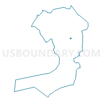
Voting District 2900020, Queens County, New York
About
Outline

Summary
| Unique Area Identifier | 635142 |
| Name | Voting District 2900020 |
| County | Queens County |
| State | New York |
| Area (square miles) | 0.06 |
| Land Area (square miles) | 0.06 |
| Water Area (square miles) | 0.00 |
| % of Land Area | 100.00 |
| % of Water Area | 0.00 |
| Latitude of the Internal Point | 40.69636190 |
| Longtitude of the Internal Point | -73.78161140 |
Maps

Graphs
Select a template below for downloading or customizing gragh for Voting District 2900020, Queens County, New York


Neighbors
Neighoring Voting District (by Name) Neighboring Voting District on the Map
- Voting District 2900011, Queens County, NY
- Voting District 2900012, Queens County, NY
- Voting District 2900014, Queens County, NY
- Voting District 2900018, Queens County, NY
- Voting District 2900021, Queens County, NY
- Voting District 3200011, Queens County, NY
- Voting District 3200025, Queens County, NY
- Voting District 3200026, Queens County, NY
Top 10 Neighboring County Subdivision (by Population) Neighboring County Subdivision on the Map
Top 10 Neighboring Place (by Population) Neighboring Place on the Map
Top 10 Neighboring Unified School District (by Population) Neighboring Unified School District on the Map
Top 10 Neighboring State Legislative District Lower Chamber (by Population) Neighboring State Legislative District Lower Chamber on the Map
Top 10 Neighboring State Legislative District Upper Chamber (by Population) Neighboring State Legislative District Upper Chamber on the Map
Top 10 Neighboring 111th Congressional District (by Population) Neighboring 111th Congressional District on the Map
Top 10 Neighboring Census Tract (by Population) Neighboring Census Tract on the Map
- Census Tract 414, Queens County, NY (4,033)
- Census Tract 264, Queens County, NY (2,257)
- Census Tract 258, Queens County, NY (1,978)
- Census Tract 434, Queens County, NY (1,956)
- Census Tract 266, Queens County, NY (1,755)